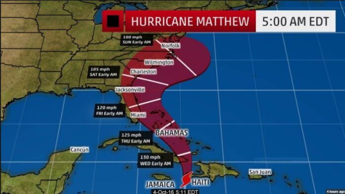
Myrtle Beach In Matthew Cone Of Certainty
As of 6 a.m. eastern standard time, the national weather service confirmed: Myrtle Beach in Matthew cone of certainty. Myrtle Beach will get at minimum some significant weather effects from Hurricane Matthew. Whether or not Matthew makes land in the United States is still too early to determine. Hurricane Matthew is projected to pass by our area between late Friday to early Saturday on its current trajectory.
Matthew became the 13th named storm of the 2016 Atlantic hurricane season. Matthew is the strongest storm since Hurricane Felix in 2007. Matthew briefly reached Category 5 hurricane status — with winds exceeding 157 mph (252 km/h) — on Oct. 1, NASA reported. Matthew dropped to Category 4 strength soon after, with maximum sustained winds calculated at a still-dizzying 140 mph (225 km/h) on Oct. 3. High-speed winds are only part of the threat that the storm poses to Haiti, with storm surges and “life-threatening rain” also anticipated, according to the National Hurricane Center (NHC) in Florida. Hurricane Matthew made landfall in Haiti early today.
It’s path takes the storm into Cuba next.
[Paid Ad – Mal Hyman For Congress]
The storm’s tracking models most resemble Hurricane Hazel. Hazel devastated Myrtle Beach in 1954.
Will Matthew ever make actual landfall? That’s a valid question. It’s certainly possible that the actual eye will never move onshore anywhere. It may stay within 15-50 miles of the coast without crossing over onto land. That falls into the ‘could be worse’ category but would still be no picnic. At the very least, all of the southeast coastline should prepare for huge waves and rough surf. With Myrtle Beach In Matthew Cone Of Certainty, that’s a given.
We should also be prepared for some tropical rain bands coming ashore, which always come with a risk of spin-up tornadoes and locally heavy rain. The biggest question mark is wind. Matthew is currently a compact storm when it comes to wind. The hurricane force winds only extend 35 miles from the center. So a storm that stays 40 miles offshore may keep the majority of destructive winds over water. A wobble 50 miles west would bring extremely damaging wind roaring ashore.
You end up with a messaging conundrum. Those 50 miles are the difference between a very damaging billion dollar disaster, and a ‘Oh, that’s all you got? What a waste to get prepared’ situation. Never a fun position to be in if you’re a meteorologist or an emergency preparedness official. The only thing we can report for now is that the weather service confirms: Myrtle Beach In Matthew Cone Of Certainty. And that’s the line forecasters are walking at this time. At the very least, I think you can expect travel disruption and some airline cancellations for Myrtle Beach by late this week.
Look for an update from us on Hurricane Matthew later this week.


